MANSALU CIRCUIT TREK
-
Trip Style
Trekking -
Activity Levels
Moderate -
Duration
18 Days -
Price (USD)
per person -
Group Size
2 pax -
Elevation (m)
Overview
“The Manaslu Circuit Trek avoids more crowded trekking routes. If its isolation, untouched natural beauty & remoteness appeals – then this is a trek for you!”
The Manaslu Circuit Trek usually means somewhere between 5-6 hours trekking every day and occasionally up to 8-10 hours while heading through high altitude passes. Manaslu is in a class of its own and is one of 14 peaks over 8000m or 21,768ft. This trek will test your endurance and may at times be difficult due to the higher altitudes, but with proper acclimatization, at lower altitudes, you will succeed. This trek will test your resolve and at times expose you to some severe weather conditions. Nevertheless, it will be an unforgettable experience. The views will leave you spell-bound and spiritually enriched. Preparation and a good level of fitness is the key to success!
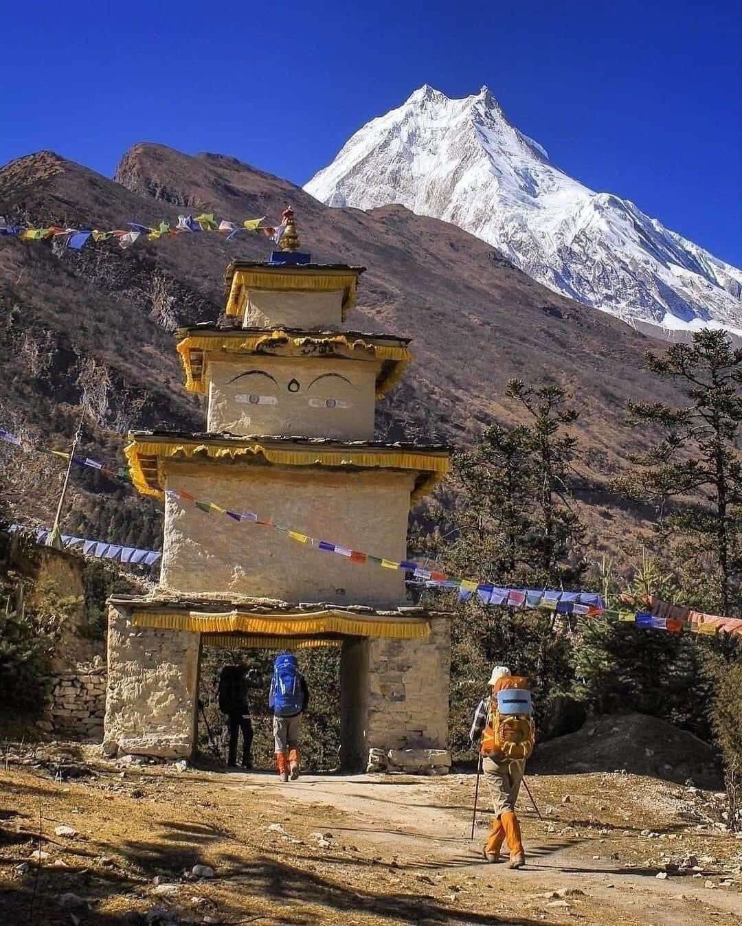
Manaslu Circuit Trek is often regarded as the trek for those who wish to see untouched beauty – and of course the iconic and majestic views of Mount Manaslu (The Spirit Mountain) Manaslu comes from the Sanskrit word Manasa, meaning “intellect” or “soul”. This trek, as the name suggests, circles the world’s 8th highest mountain – Mt. Manaslu (8,163 m) and has recently become as popular as the other well-known trails, such as Everest, Annapurna & Langtang.
Manaslu Larke (Larkye) La Pass (5,160m) is probably the most challenging day of the trek. The route takes you close to the border of Tibet, giving trekkers a taste of two cultures and their different languages. The rich cultural heritage and unbelievable beauty of the Himalayas will leave you spell-bound. The trail traverses through subtropical foothills and pastures on the Tibetan border. Its pristine and unspoiled natural landscape makes this trek unique and gives you a feeling of being remote from the world.
The Manaslu Circuit Trek is becoming more and more popular as adventure seekers share their experience. Unspoiled scenery, cultural diversity and remote lodges enhance the experience of being “off the beaten track.” If time allows we can take a short detour through the untouched and remote Tsum Valley.
The ideal time to do the Manaslu Circuit Trek is from March to May and from mid-September to December. October, when the weather is neither too hot nor too cold, is the peak trekking season due to crystal clear blue skies and uninterrupted views of snow-covered mountains. However, there are advantages of choosing off-peak times, as you will see fewer trekkers and virtually have it all to yourself! If you decide you want to do this trek in winter the Larkya La Pass will be closed by snow and you will be unable to go to Manaslu Base Camp and the Tibetan Boarder.
Manaslu Circuit Trek begins at Arughat Bazaar and follows the imposing Budi Gandaki River heading north to Deng village. Although firstly it is quite wide, the river valley soon narrows and we find ourselves walking on elevated paths above the river. Heading north, the valley widens while revealing pristine views of alpine meadows and small Tibetan villages at the base of Manaslu’s phenomenal north face. Rows of prayer flags, prayer wheels and mani stones adorn the paths as we trek through the villages. Finally, we reach samagaon, the 3rd largest village in the region. As we head west we cross the Larkya La Pass at (5213m), a well-known route that links the Budi Gandaki and the Marsyangdi rivers. As we descend we pass through the striking alpine meadows at Bimthang before connecting with the main Annapurna Circuit route and then we head back to Besisahar.
The Manaslu Circuit trek can be compared with the Annapurna trek, both offering magical views, ever craggier scenery and a high passage at Larkya-La (5100m). The difference lies in Manaslu having fewer trekkers and villages. This trek is not for the faint-hearted as the Budi Gandaki valley walls are often vertical which entails many ups and downs on steep paths as we progress toward our next destination. At times the trail is narrow and is literally a small cut-out into the rock face. The geography and cultural experience in this region is mesmerizing. The villagers living in the upper Budi Gandaki region, also known as Nupri or the western mountains, are direct descendants of immigrants who arrived here from Tibet here in the early 17th century. You will notice that in Upper Nupri the villagers are nearly all Tibetan, reflected in their dress and language. Nupri villagers paid taxes to Tibet up until around 1840a. Trade links still exist with Tibet. Nupri has some of the most awesome views, and along with the Larkya La Pass make this a feast for the eyes! Larkya La Pass is definitely the most fascinating and beautiful alpine passes in Nepal.
Most trekkers begin this journey from the village of Arughat, located 125km northwest of Nepal’s capital Kathmandu. Another option is to begin the trek from Barpak village and continue through the Rupina la Pass [4720m], or from Gorkha passing through Barpak and Laprak. The earthquake of 2015 forced trekkers to seek alternative routes. Sherpa Expedition &Trekking will discuss and advise you of the most suitable route dependent on weather and trail conditions.
NOTE: Sherpa Guide Services will have up-to-date information on conditions that will affect your planned trek. Your safety and comfort will always be our priority.
Highlights of Manaslu Circuit Trek
• View the 8th highest peak in the world at 8,163m (26,781 ft).
• Magnificent views, increasingly rugged landscape and a high altitude pass at Larkya-La Pass at 5100m (16732 ft )
• The trekking begins from Arughat Bazaar and follows the remarkable Budi Gandaki River north to the village of Deng.
• Remoteness, meaning fewer people take this route. Serene and still unspoiled with nature in its raw state.
• Walking through the tropical green hills covered with pine trees and oak forests at lower altitudes of the trek.
• The distinctive cultures and mix of Tibetan and Nepalese mountain people.
Trip Facts
Arrival City: -Kathmandu, Nepal
Departure City: – Kathmandu, Nepal
Trek Region: – Gorkha, Manang-Gandaki Zone, Nepal
Trip Style: – City Tour Trekking & Hiking
Maximum Altitude: – 5,160 M/16, 924 Ft
Trip Duration: – 17 Nights/ 18 Days
Group Size: – Minimum 1 Person Maximum 12 People
Accommodations: – Comfy Hotel in City Local Lodge During Trek
Meals: – Daily Breakfasts in City Breakfast, Lunch & Dinner During Whole Trek
Service Level: – Reliable & Friendly Authentic Sherpa Guide Clean Hotel and Lodge
Fitness Level: – Reasonable Fitness Per Day Walk: 5-8 Hours Walk & Run for Preparation
Best Time to Travel Autumn: Mid-September- December Spring: February-May
Itinerary
DAY 01: Arrival in Kathmandu and transfer to hotel. Check in hotel and rest after long flight
Your trip starts as soon as your flight reaches the sky zone of Kathmandu. The incredible snow-capped views of the Mountains surrounding Kathmandu city are enough to give you a glimpse of your upcoming thrilling trekking journey.
As soon as your flight touches the ground of Tribhuvan International airport, Sherpa Guide Services office representative and driver will be on standby at the exit terminal of the airport to receive you. They will escort you to your hotel and help you check into your hotel. After getting into your room and getting refreshed, you will be briefed about your daily activities. The rest of the time is yours to explore the neighborhood and get familiar with the surroundings.
We will have a small meeting with our senior guide in the evening where you will be briefed about the details of the upcoming trekking expedition. It's your first night in the ancient city of Temple, probably one of the best in the World.
DAY 02: Half day sightseeing of Boudhanath and Pashupatinath and trek Preparations
After a good night and a healthy and delicious breakfast, we drive for a tour of Boudhanath stupa, which is said to be the largest stupa in the world. This place is the center of Tibetan culture in Kathmandu. The stupa design feels like a huge Mandala that is a representation of the Buddhist cosmos.
Our next destination is Pashupatinath Temple. This temple is dedicated to the Hindu Deity Lord Shiva and is said to be the holiest Hindu shrine in Nepal. We can see a burning ritual of Hindus at ‘Aryaghat,’ the burning area of the temple. This cremation site is used for the once royal family of Nepal and also for the ordinary Nepalese people who live within the country.
After the amazing city tour, we return to our hotel, get refreshed, and do some shopping for the trekking. We will have an early supper and retire to our bed soon as we have to start our trekking journey tomorrow.
DAY 03: Drive from Kathmandu to Sotikhola (720m/2,362 feet)
After an early breakfast, you’ll drive west along the Kathmandu-Pokhara highway towards the Village of Sotikhola by private 4x4 jeep enjoying the scenic views. We pass through some of Nepal’s enchanting countryside landscapes, which we can see right from the windows of our vehicle.
We then cruise further towards the hill bazaar of Gorkha, an ancient historical town from where Nepal got its today's shape. The road gets a bit rutted; dirt path after Gorkha, However, you will enjoy the views of the southern slopes of Annapurna, Ganesh Himal, Manaslu, and Langtang Himal. We will reach our destination, Sotikhola, after around a seven to eight hours drive from Kathmandu.
DAY 04: Trek from Soti Khola to Machha Khola (900 m/2,920 feet)
Approx. Walking time: 6-7 hours Approx. Walking distance: 8 miles (14 km)
After breakfast in Soti Khola, you'll start this classic trek up and down through diverse landscapes including jungles, rice paddies, a cliff-face ridge, a rushing stream, and numerous gorgeous waterfalls.
We will soon start feeling the change in heights as we move ahead on our trekking journey today. We pass through the broad valley, which later on goes steep and passes through a dense forest.
The Trek begins by overpassing a bridge; before you trek through a forest, then hike onto a ridge above the huge rapids of Budhi Gandaki river (which is joined from the Tum Khola River in the Tibetan plateaus). We then arrive at Khursane upon which the rocky trail combines its way up and down, past two tropical cascades on a steep, rocky path clinging to the side of a cliff. You’ll ultimately descend past a few ride paddies, then continue up and around to the pretty Gurung village of Labubesi.
From here, you'll further climb near a rocky outcrop where the valley opens up next to the river, which flows more peacefully here. Dropping down to the river shore, you'll walk along with rounded stones before climbing over a side ridge. Head down again to the river and cross another suspension bridge to reach the village of Machha Khola.
DAY 05: Trek to Machha Khola to Yaru Phat (1,170 m/3839 ft.)
Approx. Walking time: 5-6 hours Approx. Walking distance: 17 KM
We rise early and continue to follow along the Budhi Gandaki, one of the major rivers in Nepal. The narrow path makes some little ups and downs and finally crosses the Tharo Khola and gets Khorlabesi. After a few more climbs and descends We reach the hot springs in the center of the small, terraced village of Tatopani, where we have plenty of time to soak our scruffy bodies in the flowing hot water, and then maybe go for a swim in the cold river below, drying off on the lovely river-side beach.
From the hot spring, we climb over another ridge, then cross the Budhi Gandaki on a suspension bridge. At this juncture, we climb on a wide, well-crafted staircase, then across a landslide and over a ridge to Dobhan. We will spend the night at a lodge.
DAY 06: Trek from Yaru Phat to Philim 1570 m/5,151 ft.
Approx. Walking time: 5-6 hours Approx. Walking distance: 12 KM
After breakfast in the village of Yaru Phat, We’ll cross the Budhi Gandaki twice today on a suspension bridge. Along the way, we will pass through the stone village of Jagat with its cobblestone paths.
There are numerals of Mani Walls along the route. These are stones that are engraved with Buddhist writings reflecting Tibetan inspiration. We will cross the Budhi Gandaki on a very long suspension bridge and then trek to the village of Philim where we will spend the night at a Lodge.
DAY 07: Trek from Philim to Deng Village 1,860 m/6,102 ft
Approx. Walking time: 3-4 hours Approx. Walking distance: 8 Km
Today is a stunning day of walking. From Philim, towns become few and far between. The path is shaped into the cliff that is now high over the Budhi Gandaki River. We can see wonderful waterfalls along the way, as well as watch eagles, soar the thermals high above the river. Partially through the day, we turn west and continue to follow the Budhi Gandaki. It has become narrower here as we make our way to the village of Deng. We have a great view of Mt. Manaslu and the other snow-covered peaks that surround us. Our destination is the village of Deng where we will spend the night.
DAY 08: Trek from Deng to Namrung (2630m/8626ft)
Approx. Walking Time: 6-7 Hours Approx. Walking Distance: 12.1 Miles/ 19.5 KM
After breakfast in Deng, you'll start one of the most significant and culturally important parts of the trek. First, cross the Budhi Gandaki River and climb up to the bridge. Where you'll climb a bit further to join a trail from Bhi. Then head west up the valley passing through lush jungles, alpine flora, and attractive settlements housing indigenous groups of the Manaslu region, with major peaks starting to emerge in the distance.
The track also passes across jungles and mani where we turn near a corner that contours to Ghap. Although there is alternative route, we take the route throughout Prok village. This village has a stunning viewpoint of the snowcapped Siringi Himal. Take a break here and then continue to cross the Budi Gandaki numerous times today running into several gompas along the way. The trail follows the river upstream across a dense forestry. After crossing the river at an extraordinary spot where it thunders down a narrow gorge, the jungle becomes less solid and the trail is fine again. The enjoyable hike continues and after a last vertical ascent we reach Namrung.
DAY 09: Trek from Namrung to Samagaon (3,530m/11,578 ft)
Approx. Walking time: 6-7 hours Approx. Walking distance: (10.9 miles/17 km)
After an early breakfast, we will start the trek with ascent gradually and pass through forests and reach Lihi, a fine village with many chortens and barley terraces. The path descends and traverses the side valley of Simnang Himal with Ganesh Himal continuously close by. We further pass throughout Sho, Lho, and Shyala villages before getting to Sama Village. You will have some time to rest and enjoy some glacier peaks and spectacular views of Mt. Manaslu Mountains from Lho Village, also discover the well-known Ribung Gompanear.
In Shyala village we will be encircled by high peaks like Himal Chuli and Peak 29 (Ngadi Chuli) to the left, Manaslu and large glaciers straight ahead, and other snow summits to the right, and at the far end stands Ganesh Himal. Today’s trek ends in Samagaon where we spend the night.
DAY 10: Acclimatization and explorations day in Sama Village.
Today is an altitude acclimatization day, enjoy a refreshing breakfast and then spend the day at Samagaon getting some relaxation. We get familiar with the rich Sherpa culture today. We enjoy the sight of thousands of mani stones with Buddhist manuscripts and portraits and the Sherpa women clad in old-fashioned clothes and ornaments. On a little hill near the Sama village is an old Gompa (Pungyen Gompa), a monastery with great views of the glacier. It is named after Manaslu, Pungyen means bracelet, a good explanation of the two peaks. It was demolished a year after the first unsuccessful Japanese attempt to climb Manaslu.
The locals thought that the ascent angered the gods, and when the Japanese came back a year later, they met with a lot of resistance that they had to give up their try. They were ultimately successful in 1959. Overnight in Samagaon.
DAY 11: Trek from Sama village to Samdo 3860m/12,660 ft.
Approx. Walking time: 4 hours Approx. Walking distance: (10 miles/16.5 km)
After breakfast in Samagaon, We walk down to the Budhi Gandaki River that has turned north and kept on it to a bridge over a side river today. The path to the left leads to the Manaslu Base camp.
The Larkya la Track passes numerous mani walls as the valley starts to expand. It is an easygoing path on a shelf above the river passing the juniper and birch jungles of Kermo Kharka. We drop off the ridge, cross the Budhi Gandaki on a wooden bridge and hike steeply onto a headland between two forks of the river. From a stone arch, we can view a large white Kani. Ultimately passing throughout the Kani, we reached Samdo. Overnight in Samdo.
DAY 12: Rest and another acclimatisation day in Samdo (3690m)~ Optional Hiking
It is an additional day set aside for good acclimatization. After breakfast, you can either rest in Samdo or select between two hiking possibilities: We have two alternatives hiking routes for us today. The possibility that we highly advise is a hike, up the valley directly at the back of the Samdo village. This walk will take us to one of the trade passes to Tibet for outstanding views of Mt. Manaslu along with other Himalayan ranges including Simrang, Hiunchuli, Ngadi, Larkye Peak, Cheo, and probably Kang Guru following the pass. On route to these viewpoints, we pass many seasonal herding settlements called doksas and sight some beautiful mountain birds like the Lophophorus (the national bird of Nepal), Lammergeyer, and Himalayan Griffin soaring high above us.
Our second Alternative option route for today could be a trip to the Gya La ('large pass') to the north of Samdo, a more often used trading route to Tibet. But, this is a quite long hike (full day) and therefore could be a little exhausting. Overnight in Samdo.
DAY 13: Trek from Samdo to Dharamsala/Larkya B.C. 4460 m/14, 628 ft.
Approx. Walking time: 4-5 hours Approx. Walking distance: (7 miles /11 km)
After having a hot breakfast, we start hiking down the edge, cross the wooden bridge over Budi Gandaki and start hiking upward. Upon crossing two streams and observing the Larkya Glacier we go around the valley of the Salka Khola and ascend up again to the stone guest house (4450 m), which is not a lodge but a kind of shelter called Dharmshala, also known as Larke Phedi. Be sure you have your camera ready, with fully charged batteries, as you never want to miss this chance to take the magnificent views of the mountains and enchanting natural beauties. Afternoon we have lunch and gaze out at the lovely views. You'll feel the altitude and the cold here, so enjoy a more leisurely afternoon with some tea/coffee and keep warm. We'll have an early dinner in preparation for our crossing the next high pass tomorrow.
DAY 14: Dharamsala - Larkya la 5160m/16, 924 ft - Bimthang 3720m/12, 201 ft
Approx. Walking time: 7-9 hours Approx. Walking distance: 15 miles/24 km)
This is the longest, but most interesting day; due to the high pass Larkya la 5160 m/16, 924 ft, and the views of amazing peaks. After an early breakfast, we will start with a short climb; we reach a valley on the north side of the Larkya Glaciers from where we can experience great views of Cho Danda and Larkya Peak.
Lastly, we walk throughout moraines of the glacier, making a slow ascent, which becomes steeper only in the last section of the pass. From the pass, there are outstanding views of Himlung Himal, Cheo Himal, Kangguru, and the huge Annapurna II. It is a lengthier day than normal to Bimtang, but to hike into these low terrains with the evening mist coming in with Mt. Manaslu approaching close by is a tremendous experience.
The view from Bhimtang is extremely beautiful. This village was in the 1960s hanging out for Tibetan Khampa fighters who made "attacks" against the Chinese inside Tibet, to fly to Nepal. Overnight in Bimthang village.
DAY 15: Trek from Bimthang to Gho at 2,560 meters/8,398 feet
Approx. Walking time: 4-5 hours Approx. Walking distance: 10 km
After breakfast in Bimthang, head out to a near ridge where you can enjoy great views of Manaslu, Lamjung Himal, Himlung Himal, and Cheo Himal. Keep downhill on the trail and cross a high pasture followed by a bridge over the Dudh Khola River. We hike across the rhododendron jungle and follow a trail through a narrow valley until we reach the highest cultivated land of the valley at Karche, 2785 meters.
The treks continue to go out of the alpine areas and into the most delightful valley of Dudh Khola - the milk valley. We cross the glacier river along a nice wooden bridge before it dives into beautiful silk fire and rhododendron forest, like spring, sprinkles with its red and white flowers — the trail winds in and out through the extremely fascinating valley. We come to numerous locals, such as Hambuk, Puktu, and Phute, before it goes down to the village of Gho at 2,560 meters’ altitude.
DAY 16: Trek from Gho to Dharapani 1,860 m/6,102 ft. Approx.
The last trip out of Dudh Khola is almost ending. We cross the Marshyangdi River on a long and nice suspension bridge and enter Gyasumdo, which in Tibetan means "Three Main Road Meetings," as the paths from Manang and Larkya / Gya La and the Lowlands meet here.
This is also our final day of trekking. Along the way, we will pass through the Gurung village of Tilije, noted for its well-known apple brandy that this particular village is renowned. The Gurungs are mountain people, famous for their courageousness with the Gurkha Units of the British Army. We will spend our last night of trekking at a teahouse here.
DAY 17: Drive by Jeep from Dharapani to Besi Sahar and same day drive back to Katmandu
Vehicle: Local Share Jeep and Private Comfortable Vehicle
Approx. Drive time & Distance: Dharapani to Besisahar: 35 Km (3 hrs) & Besisahar to Kathmandu: 175 km (5 hrs)
After breakfast, we take a local jeep from Dharapani and drive to Besisahar, which takes about 3-4 hours. Once we reached Besi Sahar, we change our vehicle and we drive to Kathmandu by private comfortable Car/ Hiace. It takes another 5-6 hours to arrive in Kathmandu from Besi Sahar.
The drive from Besi Sahar to Kathmandu offers an opportunity to enjoy both hill and mountain landscapes often coming into direct view with the banks of the Marsyangdi and Trishuli rivers. You'll also drive by some beautiful villages with farming terraces on both sides of the road.
DAY 18: Drive to the Airport to head back to that lovely place we call ‘home’’
After breakfast, Our Airport Guide and office vehicle will be on standby at our hotel to transfer us to the airport for our connecting flight home. Serving you was a wonderful joy and pleasure, we at Sherpa Guide Services will cherish the bonds of our relationship created over the time you spent with us and we thank you for choosing us as your travel partner and for visiting this amazing country Nepal. We are sure that trekking in this lovely region of Manaslu will give you whole lifetime of memories for the generations to come. Adios friends! Till we meet again someday.
Service Included
- Private Transfers upon arrival and departure
- Kathmandu-Sotikhola by private 4W Jeep
- 3 Night hotels in city as specified in Itinerary
- 14 nights’ local mountain lodge accommodations during trek
- Besishar-Kathmnadu by private Car
- Daily hygienic breakfast in city as specified in Itinerary
- Daily 3 meals entire trek (Breakfast, Lunch & Dinner)
- Tea or Coffee as per choice
- Welcome dinner at best local restaurant with cultural show
- Fully boiled Safe Drinking Water.
- Reliable and honest Local Sherpa guide
- Hardworking and trustworthy porters ( 1 porter for 2 People)
- Free extra luggage storage service
- Free help to get SIM Card, renting or buying gears
- Call support for anytime 24/7 for Emergency
- Pay and insurance for guide and support staff
- Special manaslu trekking entry permit fee
- Half day Cultural tour in city including guide and driver
- Entrance fees to historic sites, temples and monuments
- Local jeep transportation charges
- We help you, if an airline loses your luggage, or delayed
- International flight ticket Reconfirmation service if required
- We help our clients to buy souvenirs at wholesale price
- We show you around local areas, recommend to eat etc
- We help to buy/hire trekking gears at local price if required
Transports & Accommodations
Meals & Drinks
Support
Pays & Permit
Additional Service
Service Not Included
- International Airfare and Nepal Visa fee
- Travel insurance for emergency rescue and trip Cancellation
- Lunch & Dinner in City (approximately $ 5-10 Per Meal)
- Any Alcoholic Drinks, Water and deserts in Trek
- Gratitude for Guide & Porter after end of trek
- Phone, internet & Battery Charges bills on trek
- Unforeseen Cost such as Flight Delayed/cancellation